
How Does the Santa Barbara Breakwater Affect Downcoast Beaches?
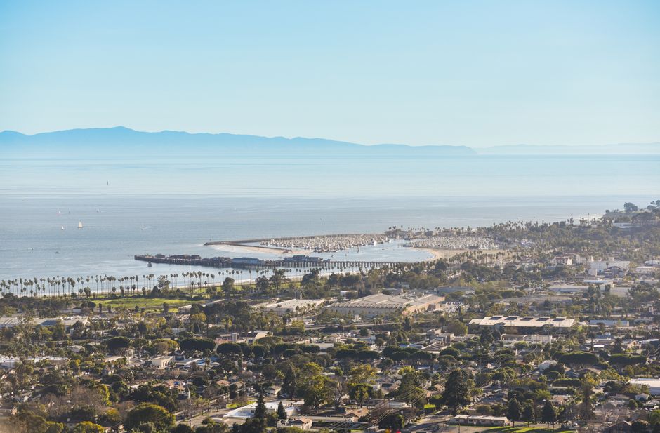
Santa Barbara Harbor’s breakwater interrupts the eastward movement of sand along the coast. Sand builds up at the harbor entrance, where it can make navigation channels too shallow, while beaches farther east receive less of the sand that once nourished them. Dredging removes the trapped sand, and placing suitable material on East Beach can return it to the downcoast flow.
What does the Santa Barbara breakwater do to the river of sand?
The breakwater blocks part of the coast’s eastward-moving supply of sand. UCSB geographer Ed Keller describes that movement as a “river of sand”: sediment from mountain streams and rivers travels along the shore toward the Hueneme Submarine Canyon.
The sand does not move as a single, visible stream. Waves and currents shift it along the coast, linking beaches into what coastal scientists call a littoral cell—a stretch of shoreline with connected sand sources, pathways, and sinks. The breakwater changes that pathway at the harbor.
The U.S. Army Corps of Engineers’ 2016 environmental assessment says the breakwater, built in 1927–28, was about 1,800 feet long and interrupted eastward sediment transport. A 1930 extension connected it to shore and impounded the moving sand.
That creates a simple coastal map: sand moves east, reaches the harbor structures, and accumulates on the harbor side instead of continuing alongshore. The structure does not create sand or erase the coast’s natural movement. It redirects where the sand settles.
Why does sand build up near Santa Barbara Harbor?
Sand builds up because the harbor entrance sits in the path of sediment moving downcoast, and the breakwater interrupts that movement. The harbor acts as a collection point for material that would otherwise continue east.
The California Coastal Commission’s 2022 staff report calls the harbor an “artificial sink” in the littoral sand system. It estimates that an average of 370,000 cubic yards of sediment entered the harbor each year over the preceding 50 years, while an average of 312,000 cubic yards was dredged annually. Those figures describe a large, ongoing transfer of sand into the harbor and out again through maintenance work.
The Corps’ assessment reports shoaling averaging about 890 cubic yards per day. In some episodes, shoaling could close federal channels within weeks. The immediate problem is practical: as sand settles in the entrance and channels, water depth falls and navigation becomes hazardous.
Long records of dredging also help researchers estimate how much sand moves along the shore. In a study of the Santa Barbara Littoral Cell, Kiki Patsch and Gary Griggs write that “average annual long-term dredging volumes should be a valuable tool for approximating littoral drift rates.” Their estimates rise downcoast from about 300,000 cubic yards per year at Santa Barbara Harbor to about 1,000,000 at Channel Islands Harbor.
The dredging numbers are not contradictory measures of one exact yearly amount. The Commission’s average describes a 50-year period, while the Corps’ assessment gives a daily shoaling average and a separate maintenance proposal allowing removal of up to 600,000 cubic yards annually. Actual dredging depends on accumulated sediment and the program in effect.
How does the breakwater contribute to erosion on beaches farther downcoast?
The breakwater contributes to downcoast erosion by trapping sand that would otherwise help replenish beaches to the east. With less sediment arriving, waves can remove more beach material than the alongshore flow replaces.
The Corps says beaches east of the harbor, previously nourished by longshore transport, experienced severe erosion. Historical analysis cited by the Coastal Commission reports that Carpinteria Beach, about 10 miles downcoast, narrowed by approximately 100 feet since 1930. The Commission also cites an association between one million cubic yards accumulated in the harbor and 38 feet of average beach-width retreat.
Those figures describe a relationship across a changing coastline; they do not mean every yard trapped at the harbor translates into a fixed amount of retreat at every beach. The useful point is the sequence: the breakwater interrupts transport, the harbor stores sediment, and downcoast beaches lose part of a natural source of replacement sand.
Keller’s UCSB account describes the same shift in shoreline terms: a wide beach formed on the west side of the breakwater, a sand spit grew near the harbor, and beaches downcoast lost sand. The harbor’s history makes the engineering tradeoff visible. A structure that shelters a harbor can also alter the sediment budget beyond it.
Dredging and sand bypassing address that tradeoff by moving sediment out of the harbor and placing suitable material downcoast. The Corps describes hydraulic cutterhead dredging, which uses a pipeline to discharge dredged sand. Its assessment says testing found the material uncontaminated and compatible with East Beach or nearshore nourishment. The Commission likewise describes placement on beaches or in the surf zone, where sand can re-enter the littoral current.
In Keller’s account, dredged sand is pumped through a pipeline to East Beach, where it can continue moving toward Ventura. This does not undo the breakwater’s interruption; it provides a managed route for some of the sand around it. The goal is to keep channels open while returning usable sediment to the coast.
Frequently Asked Questions
Why does Santa Barbara Harbor need to be dredged?
The breakwater traps sand that would otherwise continue east along the coast. That accumulation makes the harbor entrance and channels shallower, creating navigation hazards, so dredging removes sediment to maintain access.
How does dredged sand get moved back onto nearby beaches?
Hydraulic dredging pumps sediment through discharge pipes to a placement site. Suitable sand can be deposited on East Beach or in the surf zone, where it can re-enter the downcoast current.
Sources
- U.S. Army Corps of Engineers, Los Angeles District, 2016 Environmental Assessment
- California Coastal Commission, 2022 Staff Report
- Kiki Patsch and Gary Griggs, “A Sand Budget for the Santa Barbara Littoral Cell, California”
- UC Santa Barbara Department of Geography, Ed Keller, “The Story of Santa Barbara Harbor”
Read next

What Can an Affordable Whole-Genome DNA Test Tell Me?
Learn what consumer whole-genome sequencing reveals, where its health results fall short, and how to check confirmation and DNA privacy policies.